
Description
Google Earth PhotoTag
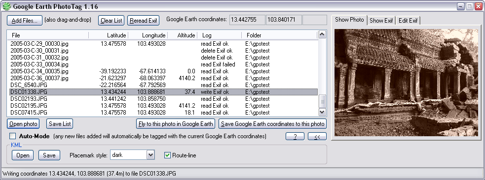
Google Earth PhotoTag is a cool piece of software that helps you add exif data to your photos on your computer and lets you check them out in Google Earth.
Easy Installation and Setup
This software is super easy to install! You won’t have to deal with a complicated setup. Just remember, you’ll need to have Google Earth installed on your device first, so it can access all the features.
Add and Edit Photos with Ease
You can browse through your computer to add pictures or simply drag and drop them into the app. It even lets you add multiple images at once, which saves a ton of time when editing!
Supported File Formats
Google Earth PhotoTag works with .jpeg, .jpg, or .phototaglist formats. It automatically shows the latitude, longitude, or altitude of your photos. Sometimes it might miss some info, but no worries—you can add it manually if needed!
View Details Easily
The app gives you a preview right inside its interface. Want to see more details? Just double-click on any photo! There’s also a separate section where you can view exif details.
Open Your Photos in Google Earth
Once you're all set with the coordinates, you can open up your photos in Google Earth directly from the app. Plus, there's an auto-mode feature that tags any new files with current Google Earth coordinates automatically!
Customize Your Experience
You can tweak how the placemark looks and even turn on options for displaying route lines. When you're done editing everything, don’t forget to save your KML file so you can check it out later!
A Great Tool for Photographers
Google Earth PhotoTag is really handy for anyone who wants to add and edit coordinates on their pictures before viewing them in Google Earth. If you're interested in checking this out or downloading it here, give it a try!
You can also find EXIF Editors collections which include this tool.
User Reviews for Google Earth PhotoTag 8
-
for Google Earth PhotoTag
Google Earth PhotoTag is a fabulous tool for editing and adding exif data to pictures. Its easy setup and multiple file editing make it a must-have.
-
for Google Earth PhotoTag
Google Earth PhotoTag offers unique geography-linked photo tagging experience
-
for Google Earth PhotoTag
Google Earth PhotoTag is fantastic! It makes tagging my photos with coordinates so easy and fun!
-
for Google Earth PhotoTag
I love how simple it is to add EXIF data to my images. This app works seamlessly with Google Earth!
-
for Google Earth PhotoTag
This app is a game changer! The drag-and-drop feature is super convenient for editing multiple photos.
-
for Google Earth PhotoTag
Google Earth PhotoTag has everything I need to organize my travel pictures. Highly recommend this tool!
-
for Google Earth PhotoTag
A must-have for photography enthusiasts! Adding coordinates to my photos has never been easier.