

Description
Well Logger: Advanced Boring Log & Well Construction Diagram Software
Well Logger is a comprehensive application tailored specifically for project engineers and geologists who need to create detailed soil boring logs and well construction diagrams. This powerful tool streamlines the documentation process for geological surveys and construction projects, allowing professionals to maintain accurate records with ease.
When you download Well Logger, you gain access to an intuitive platform that simplifies the complex task of documenting subsurface conditions. The software enables users to create thorough lithology reports that cover the entire depth of boring wells, making it an essential tool for geological documentation.
User-Friendly Interface for Specialized Work
Despite being designed for technical professionals, Well Logger offers a remarkably accessible interface that doesn't require extensive training to master. The straightforward layout allows engineers and geologists to quickly adapt to the software and begin producing professional boring logs immediately after download.
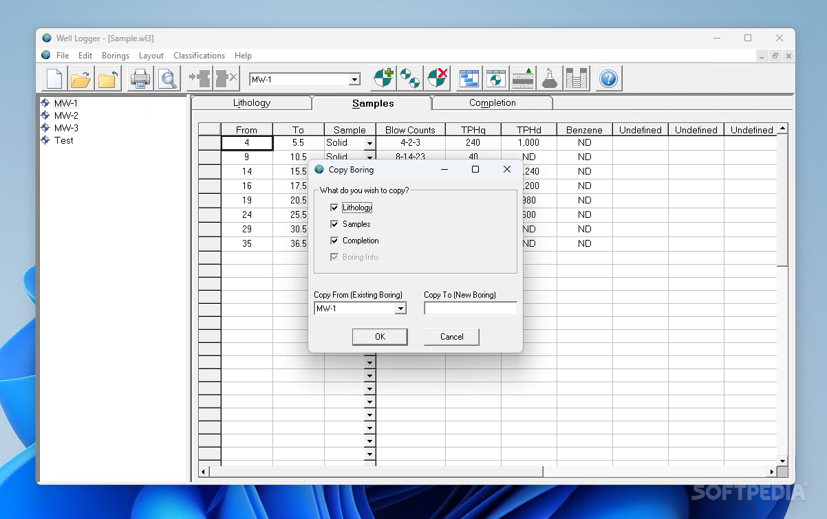
The application supports multitasking capabilities, enabling users to open several files simultaneously. This feature eliminates the need to close current projects when referencing previous work or starting new boring logs, significantly improving workflow efficiency.
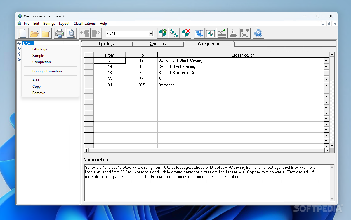
Comprehensive Layer Documentation
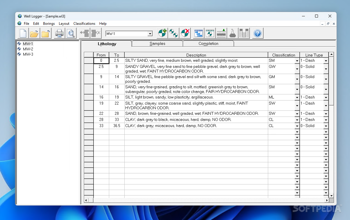
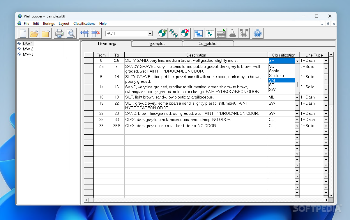
Well Logger excels in its ability to document detailed information about each geological layer encountered during drilling operations. For every layer, users can:
- Add descriptive text about the specific types of rocks and sands discovered
- Select from an extensive drop-down classification menu that includes:
- Asphalt
- Breccia
- Conglomerate
- Dolomite
- Limestone
- Shale
- Mudstone
- Siltstone
- Many other rock classifications
This systematic approach to layer classification ensures consistent and standardized documentation across all boring log projects, a crucial aspect of geological surveying work.
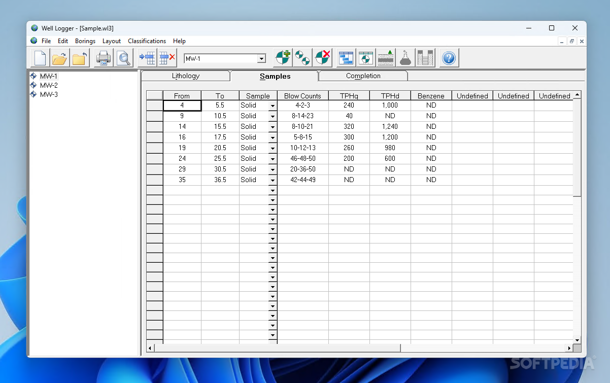
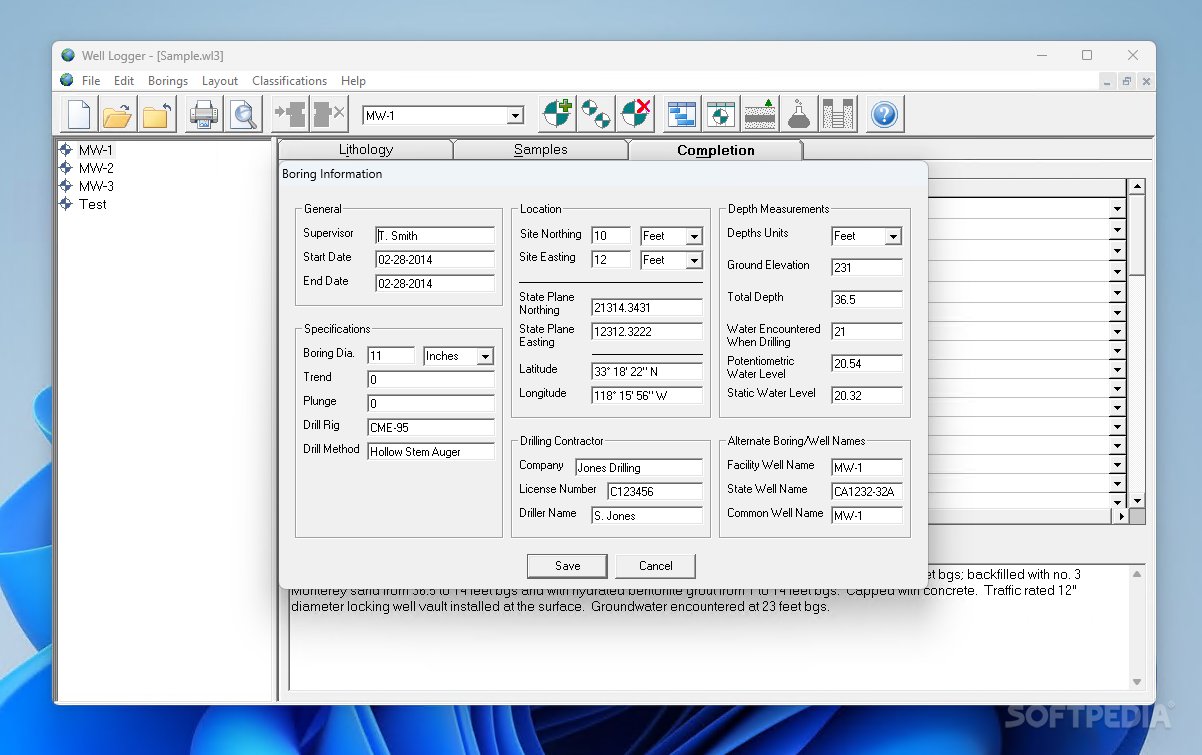
Detailed Project Information Management
The boring log software allows for extensive project metadata to be stored alongside the technical drilling information. Users can document:
- Project timeline data (start and end dates)
- Supervisor information
- Company details
- License numbers
- Drilling contractor information
- Driller names and credentials
All this information appears on the same virtual chart as the technical data, creating a complete project overview in a single document.
Technical Specifications and Measurements
- Flexible depth recording
- Ground elevation documentation
- Water encounter recording
- Dual measurement system (feet or meters)
- Precise location tracking with latitude and longitude coordinates
- Customizable variables (over 50% user-definable)
- Multi-file handling capability
The boring log application offers remarkable flexibility in how measurements are recorded, accommodating different professional standards and regional preferences. By supporting both imperial and metric systems, Well Logger ensures global usability for geological professionals worldwide.
Customization Capabilities
When you download Well Logger for your geological documentation needs, you'll discover its impressive customization options. The software allows users to add multiple lines with variables for each boring, and remarkably, more than half of these variables can be user-defined.
This level of customization ensures that the boring log software can adapt to specific project requirements and organizational standards, rather than forcing users to adapt their workflows to the software's limitations.
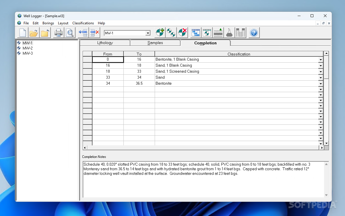
Complete Project Documentation
The location tracking feature adds another dimension to project documentation. By recording exact latitude and longitude coordinates, Well Logger creates a permanent record of where each boring was conducted, which is invaluable for future reference or additional work at the same site.
This geological documentation tool produces comprehensive reports that can serve as official records of subsurface conditions, critical for both construction planning and regulatory compliance.
Professional Applications
Well Logger serves a wide range of professional applications, including:
- Environmental site assessments
- Geotechnical investigations
- Construction planning
- Water well installation documentation
- Mining exploration surveys
- Academic geological research
The versatility of this boring log software makes it a valuable asset for any organization involved in subsurface exploration or construction.
Conclusion: A Reliable Tool for Geological Professionals
Well Logger stands out as an advanced and essential application for geologists and construction engineers who need to create complex boring logs and well construction diagrams. Its intuitive interface makes the program accessible despite its technical nature, while its comprehensive feature set ensures that no detail goes undocumented.
For professionals seeking reliable geological documentation software, Well Logger offers the perfect balance of usability and technical capability. Download Well Logger today to transform your boring log and well construction diagram process.


```
User Reviews for Well Logger 7
-
for Well Logger
Well Logger is an essential tool for geologists and engineers. The intuitive interface simplifies creating detailed boring logs and construction diagrams.
-
for Well Logger
Well Logger is an amazing app for engineers! The user-friendly interface makes it easy to create detailed boring logs.
-
for Well Logger
This app has transformed the way I manage my projects. The ability to open multiple files at once is a game-changer!
-
for Well Logger
I love how customizable Well Logger is! Being able to define variables and add descriptions helps me capture all necessary data.
-
for Well Logger
Well Logger is incredibly intuitive. It streamlines the process of drafting complex diagrams effortlessly!
-
for Well Logger
A must-have for geologists! Well Logger provides comprehensive tools for creating in-depth reports on soil boring.
-
for Well Logger
Fantastic application! It covers everything from rock classifications to project details, making my job so much easier.