


Description
ATAK-CIV (Civil Use)
Product Description
SoftPas.com offers the ATAK-CIV (Civil Use) app - a powerful tool that combines mission planning, geospatial mapping, Full Motion Video (FMV), and system administration capabilities. The application, known as the Tactical Assault Kit in DoD terminology, is designed to streamline operations by transitioning from a tactical laptop to a mobile device. This versatile tool supports Department of Defense (DoD) and commercial sector standards, making it a valuable asset for various users.
Civil Use Capabilities
- Online and offline mapping in multiple formats
- Support for very high-resolution imagery
- Collaborative mapping with customizable icons
- Overlay Manager for importing and displaying overlays with adjustable transparency
- Location marking, sharing, and history tracking
- Chat, file sharing, photo sharing, and video streaming
- Extensive navigation tools for walking, driving, and air-ground coordination
- Elevation tools, heat maps, and dynamic profiling
- Network-aware geofences and destination tracking
- Emergency features like Team Emergency Beacons
- Customizable toolbar and radio controls
- Icon support for diverse missions
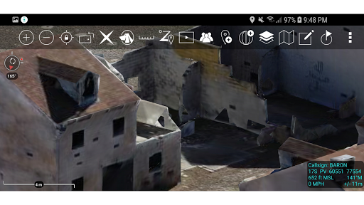
- 3D geospatial visualization
System Requirements
- Operating System: Android 5.0 (API 21) or later
- Graphics: GLES 3.0 compatible processor
- Recommended Hardware: Samsung S9 or newer for optimal experience
TAK CORE Features
- Networking capabilities for data transmission
- Geospatial data processing and visualization
- Data management for accurate information handling
Whether you're a first responder, outdoor enthusiast, or wildlife surveyor, ATAK-CIV is a valuable tool packed with features to enhance your mapping and navigation experience.
Download the ATAK-CIV (Civil Use) app for FREE from SoftPas.com now!
User Reviews for ATAK-CIV (Civil Use) 1
-
for ATAK-CIV (Civil Use)
ATAK-CIV is a versatile app for mission planning and geospatial tasks. Its extensive features and open-source nature make it valuable for various sectors.