

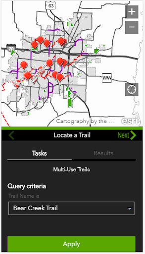
Description
GIS mapping initiatives offer user friendly viewing of highly accurate trail system waypoints. Take Go Como Trails with you to assist with route planning when searching for trail or on-street connections, trailheads, underpasses and much more. The app will also provide locations of trail amenities such as drinking fountains, restrooms or bike repair stations. The fine details are available to make your solo or family trail adventures easier to plan!
The love of trails extends outside Columbia’s borders. In 2013, the State of Missouri was named the “Best Trails State” by American Trails, a national organization working on behalf of the nation’s multi-use trails. Columbia’s trail system, via the 8.9 mile MKT Trail (aka “Columbia’s backyard gem”), connects to the cross-state Katy Trail, the longest developed rail-trail in the nation.
Go Como Trails will allow you to:
• Search Columbia’s entire inventory of destination trails
• See your location in proximity to the trail system
• Review trail surfaces including gravel or concrete
• Find trail connections to retail areas, neighborhoods or the on-road system
• Locate trailheads, parking lots, underpasses and more
• Find trail amenities such as restrooms, drinking fountains, bike fixit and exercise stations
• Review a detailed legend
• Peruse timely updates regarding trail closures due to maintenance or acts of Mother Nature
• Alert city officials to trail maintenance needs
Download Go Como Trails today for expert guidance along the way!
User Reviews for Go CoMo Trails 1
-
for Go CoMo Trails
Go Como Trails provides detailed trail information and amenities for outdoor enthusiasts in Columbia. A must-have app for exploring over 50 miles of trails!