
Description
Latin America Topo Maps
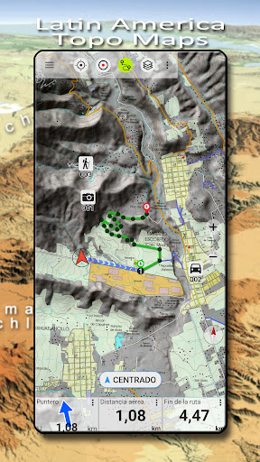
Are you an outdoor enthusiast looking for a reliable navigation app with free access to topographic maps for most parts of Latin America? Look no further than Latin America Topo Maps - a user-friendly application that turns your Android Phone/Tablet into an outdoor GPS for offline trips into the backcountry.
Key Features:
- Download map data for offline usage
- Measure paths and areas
- Create and edit waypoints
- GoTo-Waypoint-Navigation
- Create and edit routes
- Route-Navigation (Point-to-Point Navigation)
- Auto-Routing: Routes calculated on OpenStreetMap data with profiles for walking, bicycle or mountain bike
- Track Recording with speed, elevation, and accuracy profile
- Tripmaster with fields for odometer, average speed, bearing, elevation, etc.
- GPX/KML/KMZ Import/Export
- Search for placenames, points of interest, streets
- Get elevation and distance
- Customizable data fields in Map View and Tripmaster (e.g. Speed, Distance, Compass, etc.)
- Share Waypoints, Tracks, or Routes via email, Dropbox, WhatsApp, etc.
Additional Information:
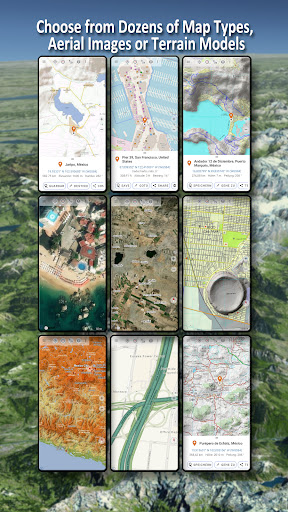
The Latin America Topo Maps app offers a wide range of map layers, including topographic maps, aerial images, and nautical charts, to help you plan the perfect outdoor adventure. Whether you are hiking, biking, camping, skiing, or engaged in search and rescue missions, this navigation app is your perfect companion.
Get Started Now!
Download the Latin America Topo Maps app for Android today and explore the beauty of Latin American landscapes with detailed and accurate maps at your fingertips.
If you have any questions, comments, or feature requests, please feel free to contact us at support@atlogis.com. We are here to ensure you have the best navigation experience possible.
User Reviews for Latin America Topo Maps 1
-
for Latin America Topo Maps
Latin America Topo Maps is a must-have for outdoor enthusiasts. Its diverse map layers and offline capabilities make trip planning a breeze.