
Description
Mexico Topo Maps
Overview
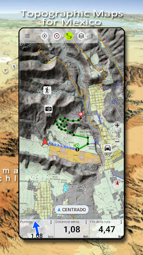
Explore the great outdoors with the Mexico Topo Maps app, designed to provide you with free access to high-quality maps and aerial imagery for Mexico. Discover a range of features and map layers to enhance your outdoor adventures.
Key Features
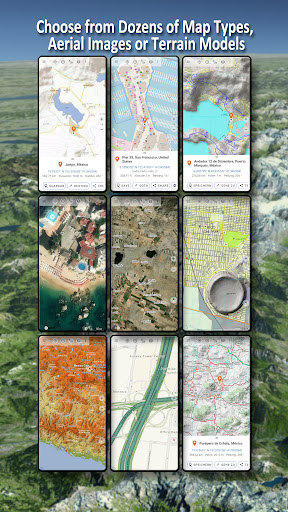
- Choose from 20+ map layers including topographical maps, aerial imagery, and road maps
- Turn your Android device into an offline GPS for backcountry trips
- Add maps from various sources such as GeoPDF, GeoTiff, and online map services like WMS
Basemap Layers
Access a range of basemap layers specifically tailored for Mexico, including:
- INEGI topographical maps at various scales
- Digital topographical and road maps
- Traditional topographical maps of the USA and Central America
Additionally, worldwide basemap layers like OpenStreetMaps, Google Maps, and Bing Maps are available for a comprehensive mapping experience.
Map Overlays
Enhance your maps with overlays that provide additional information such as roads, railroads, and geographical names for Mexico and worldwide destinations.
Main Features
- Download map data for offline usage
- Measure paths and areas
- Create and edit waypoints, routes, and tracks
- Utilize point-to-point navigation and trip recording features
- Import/export/share GPS data in various formats
- Customize data fields for a personalized mapping experience
Outdoor Activities
Whether you enjoy hiking, biking, camping, skiing, or hunting, this app is ideal for a wide range of outdoor pursuits. Plan your adventures with custom waypoints and detailed mapping tools.
Contact Us
For any questions, comments, or feature requests, please email us at support@atlogis.com.
User Reviews for Mexico Topo Maps 1
-
for Mexico Topo Maps
Mexico Topo Maps is a comprehensive app for outdoor enthusiasts, offering diverse map layers and offline GPS functionality for exploring Mexico and beyond.