
Description
New Zealand Topo Maps
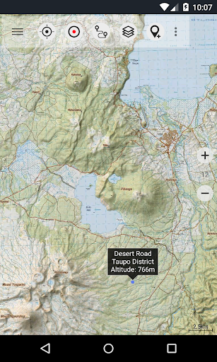
Explore the outdoors with the New Zealand Topo Maps app, offering the most recent topographic maps of New Zealand, Cook Islands, and Tokelau. With similar mapping options to Garmin or Magellan GPS handhelds, this app is your ultimate outdoor navigation companion.
Main Features:
- Create and edit Waypoints
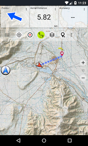
- GoTo-Waypoint-Navigation
- Track Recording (speed, elevation, accuracy profile)
- Tripmaster with odometer, average speed, elevation, etc.
- GPX-Import / Export, KML-Export
- Search for placenames, POIs, streets
- Customizable datafields in Map View and Tripmaster
- Share Waypoints, Tracks or Routes
- Use Coordinates in UTM, WGS84 or MGRS
Available Map Layers:
- Topomaps New Zealand (scales 1:250.000 and 1:50.000)
- NZMariner (RNC Nautical Charts)
- LINZ Aerial Imagery
- Google Maps (Satellite images, Road- and Terrain-Map)
- Open Street Maps
- Bing Maps
- ESRI Maps
Overlay Layers:
- Public Conservation Areas
- Open Hunting Areas
- DOC Camp Sites
- DOC Freedom Camping Restrictions
- DOC Huts
- DOC Tracks
- Taupo Trout Fishing District
- Hillshading
Use this app for a variety of outdoor activities such as hiking, biking, camping, climbing, skiing, canoeing, or offroad 4WD tours. You can preload map data for areas without cell service with the Pro version.
Limitations of the Free Version:
- Ads
- Max. 3 Waypoints
- Max. 3 Tracks
- No Routes
- No import of waypoints and tracks
- No Bulkdownload
- No Local City DB (Offline Search)
The topographic maps used in this app were created by Land Information New Zealand (LINZ) and are part of the official topographic map series used by New Zealand emergency services.
How Topographic Information is Used:
- Defence planning by New Zealand's defence forces
- Location and routing for Search and Rescue, defence, ambulance, fire service, police, and civil defence agencies
- Land management by local government and various businesses
All maps have additional labels for better readability and are rendered with Atlogis® hillshading to enhance topography.
Topo Map Coverage:
- New Zealand and Islands at scales 1:50.000 and 1:250.000
- Cook Islands at scale 1:25.000
- Tokelau Islands at scale 1:25.000
Send comments and feature requests to nzmaps@atlogis.com
User Reviews for New Zealand Topo Maps 1
-
for New Zealand Topo Maps
New Zealand Topo Maps is a fantastic outdoor navigation app with detailed topographic maps and diverse base map layers. Perfect for hiking, biking, and more!