
Description
South Africa Topo Maps Free Download - SoftPas
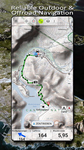
Easy to use outdoor navigation app with free access to the best available maps and aerial imagery for South Africa. The NGI (South Africa's national mapping organization) 1:50.000 topographical maps offer more detailed information compared to other map providers.
Key Features
- Download map data for offline usage
- Measure paths and areas
- Create and edit waypoints
- GoTo-Waypoint-Navigation
- Create and edit routes
- Route-Navigation (Point-to-Point Navigation)
- Track recording with speed, elevation, and accuracy profile
- Tripmaster with fields for odometer, average speed, bearing, elevation, etc.
- GPX/KML/KMZ Import/Export
- Search for placenames, POIs, streets
Map Layers
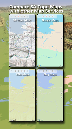
Choose from a variety of base map layers for South Africa and worldwide, including:
- South Africa Topo Maps
- South Africa Aerial Imagery
- OpenStreetMaps, Google Maps, Bing Maps, ESRI Maps, Waze Roads, Earth At Night
Additional Features
- Toggle between different map layers
- Compare maps to find the best route
- Add custom waypoints
- Import/export/share GPS waypoints, tracks, routes
Enhance your outdoor navigation experience with South Africa Topo Maps. Perfect for activities like hiking, camping, skiing, and more. Explore the great outdoors with confidence using this reliable app.
For any inquiries or feedback, feel free to reach out to support@atlogis.com. Start exploring today with South Africa Topo Maps!
User Reviews for South Africa Topo Maps 1
-
for South Africa Topo Maps
South Africa Topo Maps provides detailed topographical maps and aerial imagery. Great for outdoor activities like hiking and skiing.